
Haskill Basin Watershed Council
The Haskill Basin Watershed Council (HBWC) is a group of dedicated citizens whose mission is to maintain and enhance the chemical, biological, and physical integrity of Haskill Creek through a voluntary and cooperative effort. The formation of HBWC, in 2000, was initiated by the Flathead Conservation District (FCD) in response to growing community concerns about the impacts of various human-caused disturbances on private land throughout the Haskill Basin Watershed. Since its inception, HBWC has worked consistently and productively in pursuit of its mission, and FCD has partnered with it as an advisor and fiscal manager.
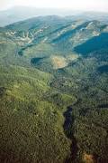
Haskill Creek originates northeast of the City of Whitefish at the Whitefish Mountain Resort, and it flows approximately 11 miles to its confluence with the Whitefish River. Haskill Creek has three main tributaries, First Creek, Second Creek, and Third Creek, all of which comprise Haskill Basin. Second and Third Creeks are the primary source of the municipal water supply for the City of Whitefish. The entire Haskill Basin Watershed covers approximately 8,200 acres, of which 53% is privately owned, 41% is owned by the U.S. Forest Service, and 6% is owned by the State of Montana. In recent years, sediment production from point and non-point sources has increased throughout the Haskill Basin due to a variety of anthropogenic modifications, including land cover disturbance, physical stream straightening, and floodplain encroachment, as well as residential and commercial developments.
Activities
- Haskill Basin Road Culvert Replacement (2017-2018). Th
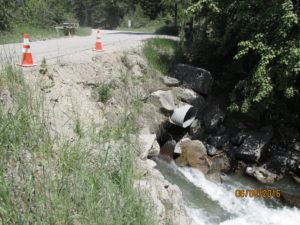 e culvert crossing at Haskill Basin Road was identified in a 2003 watershed assessment as a priority restoration site on Haskill Creek. The existing 7.5-ft diameter culvert and 2.5-foot diameter relief culvert are undersized, poorly aligned, and perched, all of which constrict hydraulic flow, prohibit fish passage, and exacerbate bank erosion at both the inlet and outlet.We received a state HB223 grant in 2017, which allowed us to hire Robert Peccia Associates and River Design Group to complete Phase I of a culvert replacement project (data collection and site survey, culvert analysis and sizing, and generation of a hydraulics report). This final engineering report will help us to more effectively leverage funding for Phase II (construction). Now that we have a hard estimate based on a thorough engineering investigation, we can apply for grants for the actual construction of a new culvert.
-
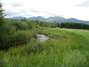
Restoration project completed at Voerman’s, 2010 Voermans/Klungness Restoration (2005, 2007). This project restored approximately 1,200 feet along the creek by re-establishing hydrologic connectivity between the active channel and the floodplain. The banks were stabilized using vegetated soil lifts, large woody debris jams, and dormant willow cuttings; also, woody shrubs were planted on the floodplain terraces. The restoration work decreased the erosion potential in the area from extreme and very high to high and moderate, and it resulted in an 86% reduction in sediment going into Haskill Creek. Funding was provided by the Montana Fish, Wildlife & Parks Future Fisheries Improvement Program (2005), the Montana Department of Environmental Quality 319 program (2007), and FCD.
- Hydropower Resolution (2011). With the support of HBWC, the Whitefish City Council passed Resolution 11-35 on September 6, 2011. This resolution limited the amount of water the City of Whitefish can divert from the Haskill Basin to that which is required for its municipal water supply (i.e., water in excess of this amount cannot be diverted from the basin for use in generating hydropower).
-
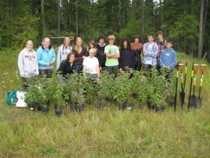
Whitefish High School’s Project FREEFLOW helps with the restoration plantings on Reimer Reach of Haskill Creek, 2012 Reimer Reach Floodplain Renovation (2012). Bank-related erosion and sedimentation were reduced along a 1,222-ft stretch of Haskill Creek using two bank-stabilization techniques as demonstration projects. The techniques were implemented at five sites: four of the sites used woody debris jams with willow cuttings and the fifth site employed a soil lift/willow hedge brush and conifer fascine. High streambanks were excavated to create new benches to re-establish connectivity between the channel and the floodplain, and a vigorous riparian buffer was planted using containerized woody plants. Students from Whitefish High School’s Project FREEFLOW program provided volunteer labor and project monitoring, which facilitated service-learning opportunities and community building. Effectiveness monitoring revealed that bank erosion and sedimentation were reduced at all five sites (97 tons/year of sediment total; approximate reduction: 74%), and native vegetation in the riparian buffer was well-established. Detailed information can be found in the project final report. Funding for this project was provided by the Montana Department of Environmental Quality 319 program, Montana Fish, Wildlife & Parks Future Fisheries Improvement Program, and FCD.
- Reservoir Management Plan (2012). The City of Whitefish, at the request of HBWC, agreed to hire a contractor to measure the amount of water spilling over the reservoir dam. In 2013, Applied Water Consulting, LLC completed the report- City of Whitefish Haskill Basin Reservoir Management Plan that provided a basic understanding of the hydrology of Second Creek and Third Creek as they relate to the operation of the Whitefish Water Treatment Plant. In 2016, the Whitefish Lake Institute (WLI) submitted a DNRC RRGL grant application- Whitefish Water Treatment Plant and Resource Optimization Project. The objective of this project is to improve overall water treatment plant efficiency to conserve water and provide in-stream flows to the Haskill Creek fishery, while improving water quality in Viking Creek. Project partners include; HBWG, WLI, Flathead Conservation District, City of Whitefish, Whitefish County Water District, Whitefish High School Project FREEFLOW, and Anderson-Montgomery Consulting Engineers.
- Flow Monitoring (2014). A flow monitoring gaging station was installed on Haskill Creek at the Monegan Road crossing. FCD and the City of Whitefish each contributed half of the station installation costs, and the Whitefish Lake Institute secured the contract for gage installation and calibration. The data will allow the partners to monitor creek flow rates, and, ultimately, estimate nutrient loadings. Flow monitoring information from 2014 is available here.
- The Haskill Basin Conservation Easement. Concerned about development in the Haskill Basin watershed, The Trust for Public Land secured an option to purchase development rights on 3,022 acres of F.H. Stoltze Land & Lumber Company land. The $16.7 million necessary to pay for the easement came from a variety of sources, including the City of Whitefish and two federal programs – the U.S. Forest Service’s Forest Legacy Program and the U.S. Fish & Wildlife Service’s Habitat Conservation Plan Land Acquisition Program. Stoltze also generously agreed to sell the conservation easement at a significant discount below the appraised value, and Whitefish voters approved a 1% resort tax increase which helped finance the easement that permanently protects 75% of the city’s water supply. The Trust for Public Land, Montana Fish, Wildlife & Parks, and the City of Whitefish purchased and finalized the easement in February of 2016 resulting in the removal of development rights, permanently protecting the City’s municipal water supply, continued sustainable management of the timber, and guaranteed recreation access. Whitefish Legacy Partners has undertaken the design and organization of a managed recreation trail on the easement land.This video from the U.S. Forest Service Forest Legacy Program provides an overview of the program’s national accomplishments and highlights the Haskill Basin conservation easement project.
Forest Legacy Program: Montana from Peregrine Productions LLC on Vimeo.